| |
| |
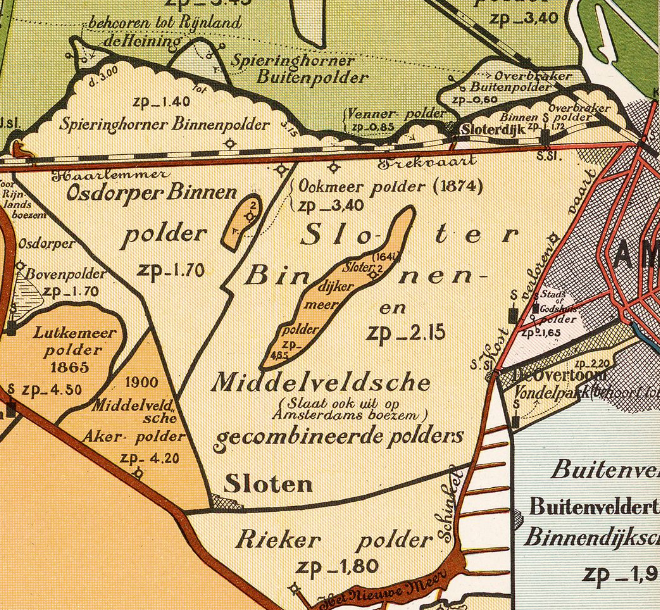
Sloterplas is a lake that was engineered in 20th-century west metropolitan Amsterdam where there had been a natural lake until 1644.
| |
Before people began settling in about 1100 CE, all of west Netherlands was delta clay, sand, peat bogs, and wet grasslands occasioned by meandering rivers and lakes of changeable size. Slotermeer was a shallow body that would vary seasonally - a lake in the sense that it was usually covered by water.
Just lower than the surrounding property, Slotermeer was a wetland until the Dutch Golden Age. The riches of that era, some new technology, and a demand for arable property enabled its reclamation.*
Keeping land dry had long been practiced by the early 1600's and was essential to the development of these low lands, but drainage was only possible with the water-pumping windmill.
The new land, surrounded by dikes and dried — impoldered — became Sloterdijkermeerpolder.
Sloterdijkermeerpolder flooded six times between 1647 and 1726, due to breaches in the dike system. After each flood, and each repair job, the polder's windmill pumped its land dry; but it was in a dangerous area, and was difficult to maintain. The district of Sloten was endangered on two sides: an arm of the sea to the north, and the big lake Haarlemermeer to the west. Haarlemermeer was growing and swallowed villages in the 17th and 18th centuries.
The famed engineer Jan Adriaanszoon Leeghwater called in 1641 for the drainage of Haarlemermeer. It would have been a massive project, requiring 200 windmills, to drain and keep dry a lake that had grown to cover nearly 170 square kilometers. The lake would remain in place for two centuries and would be a threat until the invention of the steam engine.
In the autumn of 1836, a storm overwhelmed the control systems and the whole of Sloten up to the edge of Amsterdam fell under water. This provided incentive and prompted a decision to finally drain the Haarlemermeer and be done with its danger.
The reason for a new lake within residential/commercial-zoned land was not primarily for its recreational nor esthetic value, but for the harvest of sand. The reborn (and much-deeper) lake provided material to raise the outlying neighborhoods.
World War II slowed plans for the dredging of the site of the former Slotermeer. But after the war, and with a renewed urgency for new housing, the city proceeded with its expansion plan. Sloterdijkermeerpolder was dredged and its material spread over wide areas of Sloten between 1948 and 1956.
The modern Sloterplas, at 30 meters, is deeper than most of the Netherlands is high.
| |
* The English term "reclamation" is a misnomer referring to a process of claiming land, not of reclaiming it. The Dutch term "landwinning" is more accurate.
↑ Return to "reclamation" ...
| |